In the first episode we approached how to identify and classify a landslide; then the landslide needs to be monitored to assess its evolution in time and space.
Landslide monitoring
 A landslides can be monitored through various techniques.
Monitoring of a landslide is defined as the periodic and/or permanent data acquisition and analysis of a series of observations over the time to gather information about temporal changes of specific landslides.
Landslide monitoring comprises a number of different tasks that, at the end, influence the choice of the optimal technique. Continuous use of flexible and reliable monitoring methods is essential to understand the specifics of sliding processes, to assess the landslide extent and to assess the displacement rates and changes in the surface topography.
Related practices in various parts of the world show that a good understanding of the landslide dynamics is necessary to reduce the landslide hazard and to develop appropriate mitigation measures. Consequently, continuous measurement of surface displacement patterns using appropriate monitoring methods represents an effective method of researching and understanding landslides dynamic. Monitoring, as a component of an Early Warning System (EWS), has proven beneficial in the process of planning and evaluating the effectiveness of mitigation measures.
Landslides can be monitored through the following techniques:
- Remote sensing techniques
- Geotechnical and hydrological monitoring
- Geodetic measurements
- Geophysics
Remote sensing techniques
Intended as photogrammetry and ground-based mobile units to airborne or satellite platforms using LiDAR, optical, and radar sensors.
This group includes remote sensing methods where the sensor is located at some distance away from the phenomena being observed. The benefit of remote sensing methods is that they allow us to cover large areas relatively quickly. These methods are one of the most prominent in discovering, mapping and identification of landslides, especially for long term monitoring, and offer a quick way to track morphological changes..
A number of methods for monitoring landslides are made possible using remote sensing techniques:
- Passive optical sensors: Imaging using passive optical sensors or photogrammetry is a three-dimensional measurement process that enables the determination of 3D motion vectors in long-term landslide monitoring. Images can be acquired by satellites, aircraft, helicopters, or remote unmanned aerial vehicles (UAV) as well as from a ground-based observation points using such equipment as film cameras, digital cameras, scanners, among others.
- Active optical sensors: Active optical sensors use short pulses of laser light beamed from an aircraft or a standpoint. Laser scanning can accurately determine the location, distribution and nature of the surface.
- terrestrial laser scanning (TLS)
- aerial laser scanning (LiDAR)
- Active microwave sensors: Recently, a large body of research has relied on the use of space-borne and ground-based Synthetic Aperture Radar (SAR) interferometry, which is able to detect displacements with a high degree of accuracy. SAR interferometry (InSAR) allows for DEM construction from radar images acquired from two different points of view.
- Differential SAR interferometry (DInSAR) – is based on detecting differences between interferometric pairs.
- Persistent Scatterer SAR interferometry (PSInSAR)
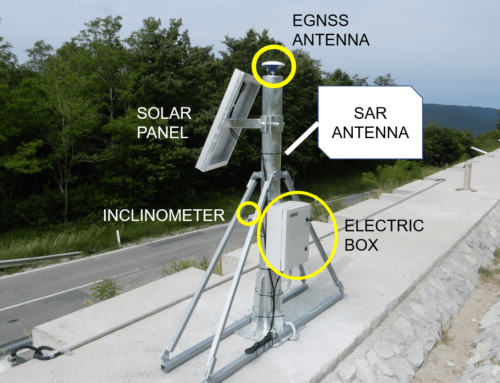
- Ground-based SAR interferometry (GBInSAR) is based on radar interferometry with a ground-based microwave interferometer. In comparison with other techniques it provides a significantly higher image acquisition rate than the space-born radar methods and enables real-time monitoring of landslide displacements.
Geotechnical and hydrological monitoring
Geotechnical and hydrological techniques provide information about the subsurface properties and changes. Geotechnical sensors are often placed within the landslide body and out of sight and provide subsurface deformation in structural data.
Techniques:
- extensometers – instruments designed to measure the change in distance between two points. Typically, extensometers are installed in boreholes and measure the change in distance between points in that same borehole (typically vertical), but they could be used also for horizontal displacement observation.
- inclinometers – are devices for monitoring movements normal to the axis of boreholes.
- piezometers – are used to monitor the ground water level and to determine the pore water pressure.Typically, piezometers are permanently installed and sealed in boreholes.
Geodetic measurements
Among of all existing landslide monitoring techniques, geodetic measurements usually provide the highest accuracy; in some cases, even sub-millimeter levels of accuracy. The results of geodetic measurements are precise, absolute 3D coordinates of points on the surface, as well as absolute changes in position. These measurements provide an invaluable framework for landslide motion monitoring.
Techniques:
- GNSS – stands for Global Navigation Satellite System and describes a system of satellites, ground receivers and ground control stations that allows accurate absolute positioning of a receiver anywhere on Earth.
- tachymetric measurements using total station represent classic geodetic techniques that are based on measurements of horizontal and vertical positions of object points installed on the surface.
Geophysics
Geophysics is based on the acquisition of physical characteristics of layers in the subsurface. Variation of physical parameters corresponding to 1D, 2D and 3D information can be deduced. Geophysics is applying usually complementary to geotechnical methods and provide information about the thickness and the volume of sliding material, and lithology.Techniques:
- seismic tomography;
- electric tomography;
- georadar sounding;
- gravimetry.


